
Have you ever had to conduct a site survey for an outdoor area, it might be fine if only a very small area, clicking everywhere you stand/ walk, but imagine doing a city block or a mine site, this would be come very hard to manage. This is why site survey software normally supports a GPS option. This blog post will show how to utilise the GPS Receiver to conduct an outdoor Site Survey using Ekahau Site Survey Software.
Requirements:
Hardware:
- A Supported GPS Receiver (See below for details of supported GPS Receivers)
- Laptop or Tablet Computer with ability to connect the GPS (I’m using a Surface Pro 4 with a USB Hub attached)
Software:
- Windows Operating System
- Ekahau Site Survey
- Franscon GpsGate (Installed during Ekahau Site Survey’s installation. Or can be installed later by Going Start > All Programs > Ekahau > Ekahau Site Survey > Install GPS Support
Supported GPS Receivers
A GPS receiver is required for the GPS survey feature to work. The following GPS receivers are supported:
- Bluetooth GPS devices, that support NMEA
- USB GPS devices that support NMEA, Garmin Protocol or Trimble TAIP
- Network connected GPS devices (usually using TCP/IP or UDP), that supports TAIP or NMEA
- GPS devices connected to PC-CARD that supports NMEA
- GPS devices that are connected to an RS-232 port, that support NMEA, Garmin or TAIP
I use a GlobalSat G-STAR IV Model BU-353S4
Steps to perform the survey
- Connect a GPS receiver to your laptop
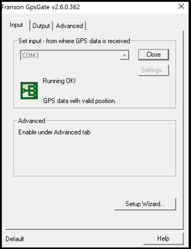
- Turn on the receiver; make sure it is outputting data in one of the supported formats. You will need to be outdoors for the GPS receiver to work properly. (You can use GPSGate to check this)


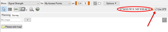
- In the user interface, check the Use GPS checkbox. If you do not see the Use GPS checkbox in the top-right corner of the user interface, ensure that you have purchased ESS Professional version.
- If your GPS device has not been previously configured, a GPS configuration dialog will pop up. Typically, the default settings are recommended. When asked “Do you want to use this device”, select Yes. In the output selection, ensure that the “share my GPS between several applications” option has been selected.
- Place 3 GPS reference points on your map using the GPS Reference Point Tool on the Survey tab. You either need to know the latitude/ longitude of the points or alternatively you can use the GPS to complete these but you need to be physically there.
- To ensure measurement accuracy, take the reference points at least 300 meters (1000 feet) apart from one another, and don’t place the reference points on a straight line.


- Now you should see the blue circle on the map, indicating your current location. If it is not, check if you see an exclamation mark next to the Use GPS button. If so, move your mouse over the exclamation mark to see the error.

- In the Survey tab, click the GPS Record button to start the survey – it will change from GPS Record OFF to GPS Record ON.

- Drive or walk throughout the outdoor area you wish to survey.
- To end the GPS Recording by clicking the GPS record ON button and then click on the Arrow icon to end the survey.


- Recommend to save the survey – either by clicking the Save Icon or using the File > Save/ Save As… option

A useful video from Ekahau on conducting a GPS Site Survey located here:
Ekahau also provide very useful documentation on this here.
Things I wish would be added to the Software
One thing that I wish Ekahau would add to ESS is the ability to export the survey results and survey paths to mapping products like Google Earth Pro/ Nearmaps etc, so I can have better zoom and pan controls whilst viewing the survey. The 3D maps in Google Earth Pro also look cool when popping out of the coverage overlay and impress management. This is one feature that Airmagnet offers over ESS at this stage.
The other thing that would be nice is to import the map from a mapping product, to save me having to download one, scale it and put GPS markers on it etc.

Hi Haydn,
Thank you for the excellent blog post. Now that we have Sidekick out of the way, we’re concentrating more on the future products, including future survey products. Of course, one topic there will be GPS improvements as well…
Perhaps we should discuss about this at some point once we start moving forward with the GPS stuff (will take a few months still).
—
Jussi / Ekahau
LikeLiked by 1 person
I’m looking forward to getting my hands on a Sidekick to put it through its paces, hearing good things about it. Will be keen to see what Ekahau does with the GPS stuff moving forward.
LikeLike
Nice share & the product seems good too & promising but conducting outdoor surveys needs a device that can collect data even when there is no internet connection.
LikeLike
Hi Brewsurveyapp
You do not require internet access when conducting surveys with Ekahau and the GPS.
If you like I can pass on some details of your local Ekahau SE to give you some further information on their product
Haydn
LikeLike
Pingback: Ekahau GPS Survey on Windows